Africa Can Swallow the US, Canada, the UK, the EU and Australia
Place the contiguous United States, Canada, Australia, Britain and the European Union inside Africa and they fit. The UN's new map initiative reveals how badly our familiar world map concealed that scale.
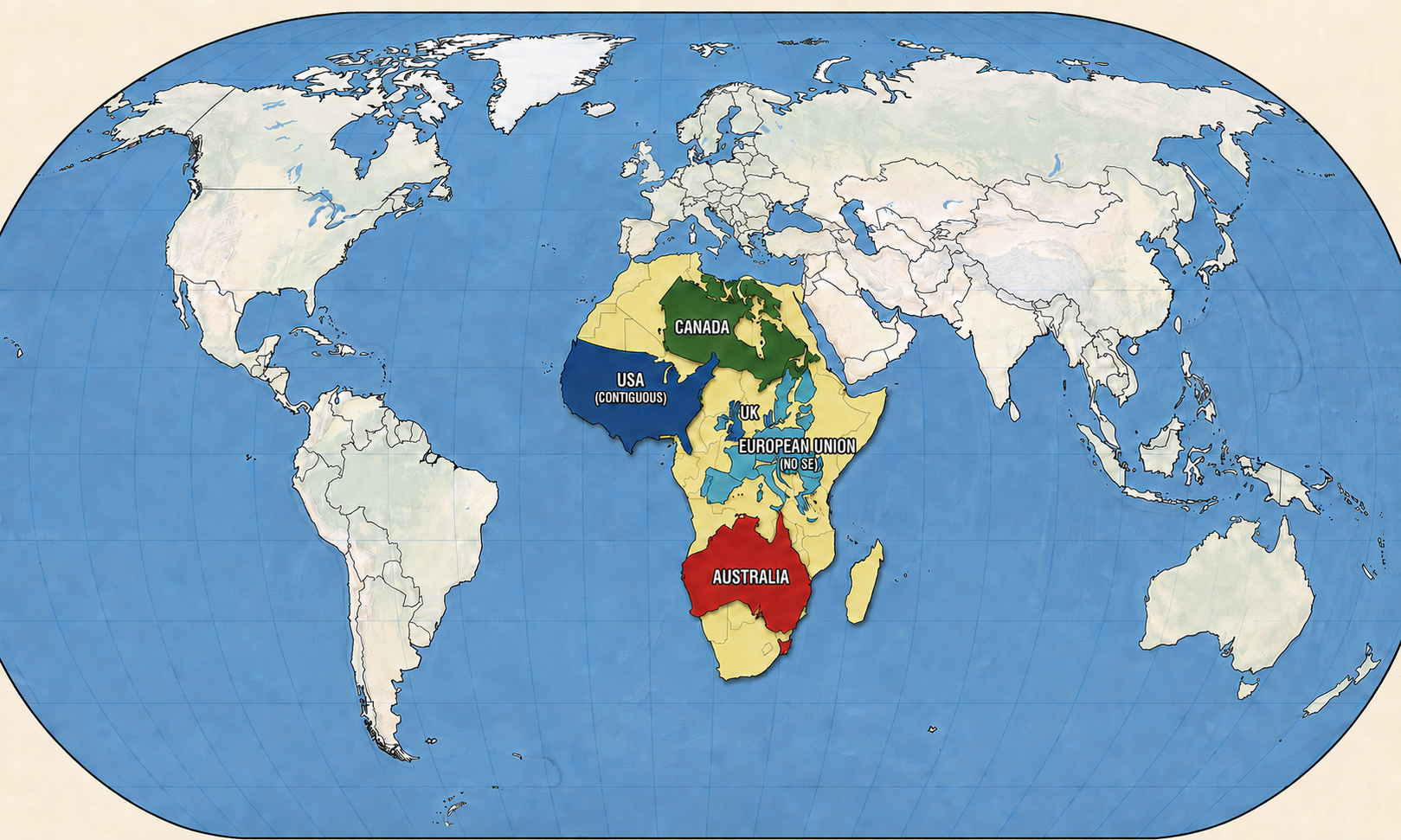
Take the entire contiguous United States, all of Canada, the United Kingdom and the massive landmass of Australia. Now squeeze in all 27 nations of the European Union.
Drop them inside the borders of Africa.
Every single one fits.
It sounds like cartographic fiction because familiar maps have distorted our sense of scale for generations. Europe looks formidable, Canada dominates the northern horizon and Africa seems like just another continent in the middle.
Yet the arithmetic tells an astonishingly different story.
Africa covers roughly 30.37 million square kilometres. Start stacking the pieces: Canada (9.98 million sq km), the lower 48 United States (8.08 million sq km), Australia (7.69 million sq km), the 27-nation European Union (4.23 million sq km) and the United Kingdom (0.24 million sq km).
Combined, this heavyweight geopolitical roster totals approximately 30.22 million square kilometres.
They fit within Africa’s total area with roughly 148,000 square kilometres remaining: about the size of Nepal and larger than Greece. Africa is nearly twice the size of Russia, three times the size of Europe and 14 times larger than Greenland, which Mercator maps routinely draw as Africa’s equal.
Now, after more than four centuries of optical illusion, the world is finally moving to correct the picture.
A Global Reckoning with a 450-Year-Old Map
On September 4, the United Nations General Assembly endorsed a resolution urging governments, schools and international bodies to move away from the traditional Mercator projection in favour of true-to-scale representations such as the Equal Earth map.
A specialised sea-navigation tool quietly hardened into humanity’s default mental picture of the Earth.
Sponsored by Togo on behalf of African states, the measure passed decisively with 164 votes in favour. The United States cast the only vote against it and six nations abstained. Both the United Kingdom and France supported the resolution, while France’s foreign ministry announced that it would stop using Mercator maps.
The resolution is non-binding. It will not ban Mercator from maritime charts, where its preservation of direction still serves a purpose. Instead, the initiative targets something deeper: unseating a flawed visual standard that has quietly shaped our perception of global importance for hundreds of years.
The Sailor’s Mathematical Trick That Warped the Planet
The distortion dates to 1569. Flemish geographer Gerardus Mercator was not playing geopolitics; he was helping sailors navigate oceans.
His chart let navigators draw a straight line between ports and follow a constant compass bearing. But a three-dimensional sphere cannot be flattened onto a sheet without distortion.
Mercator chose his compromise intentionally: preserve straight navigational lines by stretching the poles.
The farther a landmass sits from the equator, the more dramatically inflated it becomes on the page.
The formula worked for navigation. Trouble began when it migrated from ship cabins into schools, atlases and news broadcasts. A sixteenth-century geometry solution became humanity’s default picture of Earth, rendering the Global North vast and prominent while quietly diminishing equatorial landmasses.
Why the Canvas Matters
Rethinking classroom wall maps will not pave a single kilometre of road, build new ports or untangle diplomatic conflicts overnight. Raw acreage does not dictate modern geopolitical power.
Yet maps shape how we imagine relevance before we analyse a trade ledger or study foreign policy. They influence assumptions about distance, economic scale, market capacity and strategic weight.
A continent capable of swallowing the territories of some of the West’s largest powers and economies was never small. The world was simply trained to look at a version that made it appear that way.